On a recent trip up the Oregon coast, a friendly doorman at our hotel in Portland was inquiring about our trip. When we mentioned we passed through Bandon, OR, he quipped that Bandon was the place furthest from a city of one million people in the USA. I guess a normal person would just think "oh, that's interesting" and move on, but it has been plaguing me ever since.
Firstly, I had to find what cities in the USA had more than 1 million people. Luckily Wolfram Alpha gives the answer:
- Chicago,Illinois
- Dallas,Texas
- Houston,Texas
- Los Angeles,California
- New York, New York
- Philadelphia,Pennsylvania
- Phoenix,Arizona
- San Antonio,Texas
- San Diego,California
(I certainly wouldn't have guessed that list!) From there my plan was to find the bounding box of the continental USA; luckily Wikipedia has the raw data for that. Combined with the latitude and longitude of the cities above, I had the raw data.
I couldn't figure out any way better than a simple brute-force of testing every degree and minute of latitude and longitude within the bounding box and calculating the distance to the closest large city; the theory being that from one particular point you would have to travel further than any other to reach a city of 1 million people. Luckily, that is short work for a modern processor, and hopefully the result would be a point somewhere around Bandon. I'd already become acquainted with the great circle and measuring distances when I did Tinymap, so a quick python program evolved.
However, it turns out that the program picks the far south-east corner of the bounding box. Thanks to the shape of the USA, that is way out over the ocean somewhere. I can't figure out a way to get an outline of the USA to test if a given point is inside the border or not, but all is not lost.
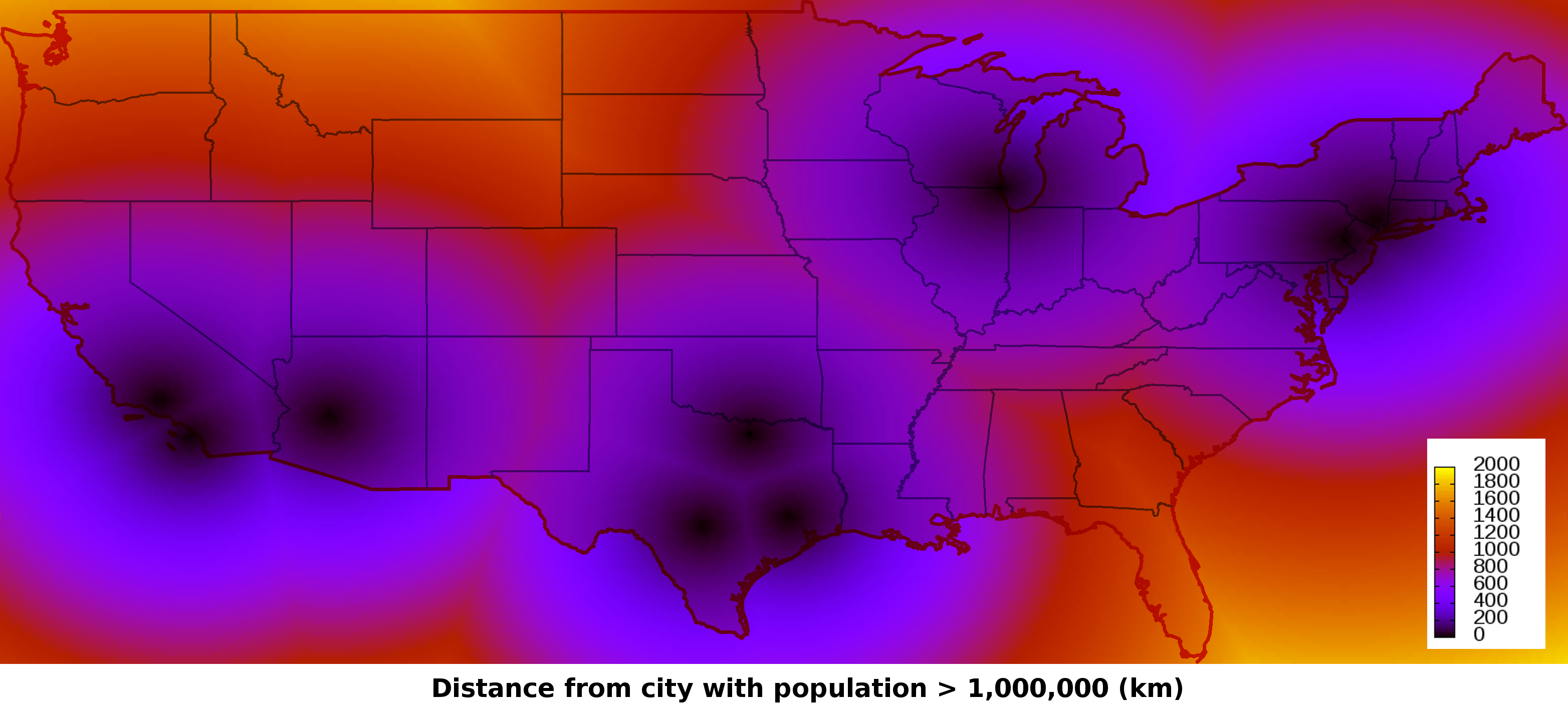
I modified the program to output the the distance to the closest large city along with the location to a log file, and then imported it into gnuplot to make a heat-map. The hardest part was finding an equirectangular outline of the USA to place the heat-map over, rather than a much more common Mercator projection; Wikimedia to the rescue!
I actually surprised myself at how well the two lined up when, after a little work with Gimp, I overlayed them (big)
From this, I can see that Bandon, about a third of the way up the Oregon coast, is a pretty good candidate. However, probably not the best; I get the feeling the real point that is the furthest from any city of 1 million people is actually somewhere in the central-middle of Montana.
However, we can also fiddle the program slightly to disprove the point about Bandon. The numbers show the closest large city to Bandon is LA, at ~1141km. Taking another point we suspect to be more remote; the closest large city to Portland (where we met the doorman) is also LA at ~1329km. So to reach the closest large city you have to travel further from Portland than Bandon, so Bandon is not the furthest place in the USA from a city of one million people. Myth busted!